A good children’s atlas can be an excellent source of inspiration and can spark an interest in exploring the world through a combination of drawings, pictures, facts and maps. It’s not just about learning more about geography, capitals and flags. It’s also about learning how climate, nature and culture impact people and shape who we are. If you’re looking for an awesome kids’ atlas with beautiful maps for children, check out our recommended books below.

Maps – our favourite children’s atlas
by Aleksandra and Daniel Mizielinski
We like the type of travel books that spark our imagination. Our kids typically get fascinated with exotic animals and food, which is an excellent starting point to learn more about a country. The starting point for wanting our children to become curious explorers of the world around them is to teach them respect for others.
The 10 Best Atlases for Kids (based on our personal experience)
While travel books are a broad genre, we have focused on children’s atlases in this post. Some of the books below focus on animals rather than on maps and might be better described as animal atlases. In any case, we think it’s a solid list, and you can’t go wrong with any of these books. Note that we own the top 6 atlases on the list below and have included 4 additional ones based on feedback from others.
It seems to me that the natural world is the greatest source of excitement, the greatest source of visual beauty, and the greatest source of intellectual interest. It is the greatest source of so much in life that makes life worth living.
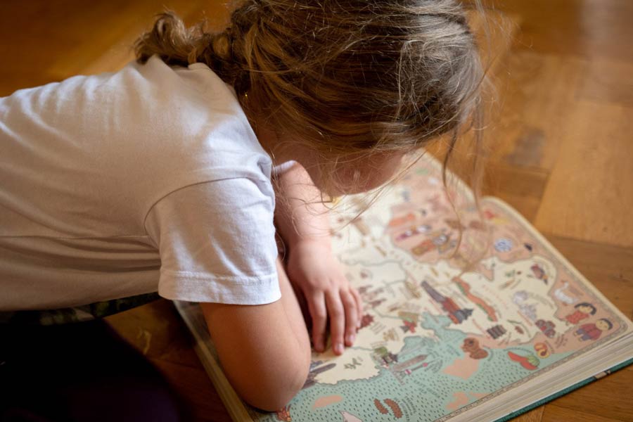
Maps – Our Favourite Children’s Atlas
By: Aleksandra Mizielinska and Daniel Mizielinski
Best for: 7-9 year-olds
Simply named “Maps”, this is our favourite children’s atlas by far, having sparked countless hours of conversations with our kids about what to see and do in different countries. The maps are cleverly illustrated, condensing the gist of each country on a double page. We think this is a fantastic way for children to explore and discover the world compared to traditional textbooks or just googling a massive amount of information. The maps show borders, cities, rivers, and mountain peaks, as well as places of historical and cultural importance, personalities, animals and plants.

Maps – Deluxe Version
By: Aleksandra Mizielinska and Daniel Mizielinski
Best for: 7-9 year-olds
This updated purple version of “Maps” covers 66 maps whereas the original (blue cover) version above covers 52 maps. Noteworthy additions vs. the blue cover version include Turkey, Iran, Ethiopia, Norway, the Baltic states, Ukraine, most of Eastern Europe (with the exception of Belarus and Moldova), the Democratic Republic of the Congo, Venezuela, Argentina, Indonesia, South Korea, Nigeria, and Cuba.
Just like the original, the individual maps are adorned with delightful artwork and are brimming with cultural, historical, and geographical insights that are pertinent to each location and its inhabitants. While there are instances where the references might come across as clichéd, it’s important to note that this book offers an introductory and somewhat whimsical exploration of humanity. Hence, it’s forgivable if it occasionally exudes a slightly “touristy” vibe, as this is all about inspiring children to learn more about the world around them.

![]()
Collins School Atlas
By: Collins Maps
Best for: 11-14 year-olds
Designed with the inquisitive young reader in mind, Collins School Atlas for kids (KS3 – KS4) is enriched with engaging anecdotes and trivia, offering insights into cultures, landmarks, and historical events that have shaped our globe. Young explorers will not only deepen their understanding of geography but also cultivate an appreciation for the rich tapestry of cultures that call Earth home.
Navigating this children’s atlas is a breeze, thanks to user-friendly features like colour-coded legends, scale indicators, and a comprehensive index. Whether delving into the mysteries of ancient civilizations, tracking the migratory paths of awe-inspiring creatures, or tracing the courses of mighty rivers, this atlas provides a holistic view of our interconnected world.

![]()
By: Emily Bone (Author), Marianna Oklejak (Illustrator)
Best for: 2-5 year-olds
Embark on an enchanting journey of discovery with the captivating lift-the-flap atlas designed especially for our youngest explorers, aged 2 to 5 years old. Every page of this delightful atlas invites little adventurers to embark on an interactive quest through the wonders of our world, igniting their curiosity and imagination.
With more than 80 engaging flaps waiting to be lifted, this atlas promises a world of surprises. As inquisitive fingers explore, toddlers and young kids will unveil the secrets that lie beneath, from the very core of our planet to the tiniest inhabitants of the lush rainforests and the mysterious depths of the ocean. Each flap brings to life the magic of exploration, revealing hidden treasures. A great children’s atlas for young kids eager to explore the world around them!

![]()
Wild Animal Atlas: Earth’s Astonishing Animals and Where They Live
By: National Geographic
Best for: 5-9-year-olds
Our daughter has always been very interested in animals and nature, and this animal atlas makes it possible to combine that passion with learning geography simultaneously. As you would expect from National Geographic, you get terrific animal photography, and colourful maps make this a fun and engaging Atlas for young readers. The animals are organised by region, including a unique feature of one to four animals in the area. The Atlas is not going into great details, but great for young preschoolers just starting to get into maps and countries.

Animal Atlas
By: Anna Claybourne
Best for: 4-8-year-olds
This book is packed with beautiful drawings of animals from polar bears in the freezing Arctic to orangutans in the humid rainforest. Animal Atlas is a lot more detailed than the book from National Geographic and is great for older preschoolers and school-age children. Especially for kids that are passionate about nature and animals, this is a great segway to learn more about geography and the world we live in. After reading this Atlas, our trips to the National History Museum became even more interesting!

The Usborne Children’s Picture Atlas
By: Ruth Brocklehurst
Best for: 4-7-year-olds
This is an excellent book for children beginning to understand the link between countries, nature and animals. We like how the book starts by explaining different natural elements like ice and snow, grasslands, lakes and oceans and then later places these elements on the maps with the animals. The maps are richly illustrated; however, they are quite high level showing whole continents so not a lot of country-level detail. Every map exhibits the countries, their capital cities, the most famous landmarks, the longest rivers and the highest mountains.

Children’s Illustrated Atlas
By: Andrew Brooks
Best for: 9-12-year-olds
This children’s Atlas is an engaging introduction to the continents and countries, taking you on a beautiful tour of our planet. From north to south, each section is brought to life with striking images and illustrations showing geography, landscape, culture and history. You’ll find more than 50 amazing maps full of fun and fresh photos followed by information about climate, population, star sites, mountains, rivers, and wildlife.

Collins Children’s Picture Atlas
By: Collings Maps, Steve Evans
Best for: 8-12-year-olds
This Collins edition is another well-illustrated children’s Atlas. The book takes kids on a journey around our planet, through continents and countries showing fun facts and exciting places to visit. Maps are easy to understand, exciting and perfect for children to use when exploring new parts of the world.

Big Picture Atlas
By: Emily Bone, Dan Taylor
Best for: 4 to 10-year-olds
This children’s Atlas contains 15 beautifully illustrated maps, where you can discover countries, continents, oceans, mountains and ice caps. The maps are cleverly combined with animals, as well as facts about each country. We also like how flags and capital cities have been seamlessly integrated for the various countries.

If you’re looking for more activities, check out our post with 100+ activities for kids at home!
By: Collins Kids (Author), Steve Evans (Illustrator)
Best for: 3-7 year-olds
This is not an atlas, but we definitely recommend this world wall map as a great way to engage children in talking about countries around the world. Full of bright colours and additional illustrations showing what each country is famous for, this is an amazing map for toddlers as well as KS1 school-age kids. From Elephants in Africa and Russian dolls in Russia to penguins in Antarctica and kangaroos in Australia, there are so many interesting details for kids to study. It costs less than £10 and has thick paper (not laminated) delivered in a tube. Our kids love asking questions about the different pictures on the map, and finding where we come from or where members of their family live around the world.

![]()
How to make your own children’s map of the world
Creating an interactive animal world map for kids is a fantastic way to combine education and creativity. This engaging DIY project teaches kids about geography, habitats, and the diversity of life while fostering their imagination. It’s a meaningful and enjoyable activity that you and your kids will cherish. So, gather your materials, set aside some quality time, and embark on a journey of discovery through your kids’ eyes!

Using the atlas to make our very own interactive animal map of the world!
Materials You’ll Need:
- A bunch of A4 sheets
- Tape
- Markers, crayons, and coloured pencils
- Animal figurines (optional)
- Animals Atlas or free online resources
Step 1: Prepare Your Canvas
- Gather several A4 sheets and tape them together to form a larger canvas.
- Sketch out the world and continents lightly in pencil, providing a basic structure for your map.
Step 2: Add Color and Life
- Provide your kids with a variety of colourful markers, crayons, and pencils.
- Encourage them to fill in the different habitats on the map. For instance, colour rainforests in vibrant green and deserts in warm yellow.
Step 3: Place Animal Figures
- If you have animal figurines, gather them for this step. If not, you can draw animals on paper and cut them out.
- Using references like National Geographic’s Wild Animals Atlas or free online resources, guide your kids in placing the animal figures in their natural habitats.
- Think about where each animal would thrive – elephants in savannahs, penguins in polar regions, and tigers in jungles.
- Let your kids’ imagination shine as they arrange the animals according to their preferences.
Step 4: Learning and Fun
- As the animals find their places on the map, use this opportunity to engage your kids in conversations about geography, habitats, and animal diversity.
- Discuss the importance of protecting these habitats and the interconnectedness of life on Earth.
Step 5: Embrace Creativity
- Remember, the goal is to have fun and learn through creativity. Encourage your kids to add their unique touches to the map.
- Whether they want to add fictional creatures or create their own imaginative habitats, let their creativity flourish.
Step 6: Display and Explore
- Once the map is complete, display it proudly in a common area where everyone can enjoy it.
- Encourage your kids to explore their creations and share their masterpieces with friends and family.

The finished world map with animals placed out on all the continents
Description:
To start this DIY project, gather several A4 sheets and tape them together to form a larger canvas. Help your child outline the continents, giving your map a basic structure. Now, it’s time for the kids to unleash their creativity! Provide them with an assortment of colourful markers, crayons, and pencils. Let them fill in the lush rainforests with vibrant greens and paint the arid deserts in shades of warm yellow. This is where the magic happens as they infuse life into their world map.
Now comes the most exciting part – populating the map with animal figurines! As your kids dive into this activity, their imaginations will take flight. They’ll intuitively place each animal figure in its natural habitat, bringing authenticity to their creation. Picture elephants roaming the vast savannahs, penguins frolicking in icy polar regions, and tigers prowling the dense jungles. They will transform the map into a living, breathing representation of Earth’s incredible biodiversity.
For inspiration, you could use resources like National Geographic’s Wild Animals Atlas as a reference. This will help guide you in accurately depicting the animals’ habitats and distribution. However, remember that this project is all about embracing creativity and personal expression, so don’t hesitate to let your kids’ imaginations take the lead.
As the animals find their places on the map, your children will not only learn about geography but also gain an understanding of the intricate relationships between different species and their environments. You can have conversations about conservation, the importance of protecting habitats, and the diversity of life on our planet.
Best atlas for toddlers
As parents, we know that fostering a love for learning and exploration in our little ones is an invaluable gift. What better way to ignite their curiosity about the world than with captivating atlases designed specifically for toddlers? Based on our own experience, these are the best atlases for toddlers we’ve come across:
1. “Look Inside Our World”: Interactive Flips Unveiling the Marvels
Imagine a world where every flip of a page leads to a new realm of discovery. “Look Inside Our World” is an atlas designed to engage and enchant toddlers in the most delightful way possible. With interactive flips that unveil captivating scenes, this atlas invites kids to explore the globe, from animals in their habitats to fascinating cultures. Each flip is a moment of wonder and excitement, fostering a connection between little explorers and the world around them.
2. “Big Picture Atlas”: A Journey of Illustrated Delight
Enter the world of “Big Picture Atlas,” an illustrated treasure trove that sparks imagination and learning in equal measure. Illustrated animal atlases like this one are tailor-made for young minds eager to unravel the mysteries of the animal kingdom. With vibrant visuals that come to life through the eyes of toddlers, this atlas is a captivating journey that introduces kids to diverse creatures and their habitats. It’s a gateway to understanding the beauty of our planet’s biodiversity.
3. “Collins Children’s World Wall Map”: Inspiring Minds on a Grand Scale
Turn a room into a realm of exploration with illustrated wall maps like “Collins Children’s World Wall Map.” These oversized wonders aren’t just decorative; they are interactive inspirations. Each corner of the map becomes an opportunity for conversations and discoveries as parents engage actively with their toddlers. Through shared discussions and stories, kids begin to grasp the concept of continents, countries, and the vibrant cultures that shape our world.
Engagement Beyond the Pages: The Key to Unlocking Understanding
While these atlases are filled with captivating visuals, it’s the active engagement of parents that truly unlocks understanding for toddlers. Engaging in conversations about the animals they see, the places they discover, and the people they learn about bridges the gap between the pages and the real world. As parents actively participate in the exploration process, toddlers begin to grasp the basic concepts of geography, diversity, and interconnectedness.
In a world full of screens and gadgets, introducing toddlers to the magic of atlases is a wholesome and immersive way to spark their curiosity. With options like “Look Inside Our World,” “Big Picture Atlas,” and “Collins Children’s World Wall Map,” the journey of discovery becomes a shared experience. So, let’s embark on this journey together, flipping pages, uncovering wonders, and nurturing a lifelong love for exploration in the hearts of our youngest adventurers.

